Search This Blog

Sunday, June 12, 2011

June 12, 2011 - Mt. Shasta, CA and vicinity

So i made it to lovely Mt. Shasta, CA. My friends Randy and Hoa Bofinger live there and it's always a pleasure to visit them.

They have the best views from their kitchen! Out one window you see Black Butte...

...and from the other, you see Mt. Shasta! And Hoa can cook like a pro.

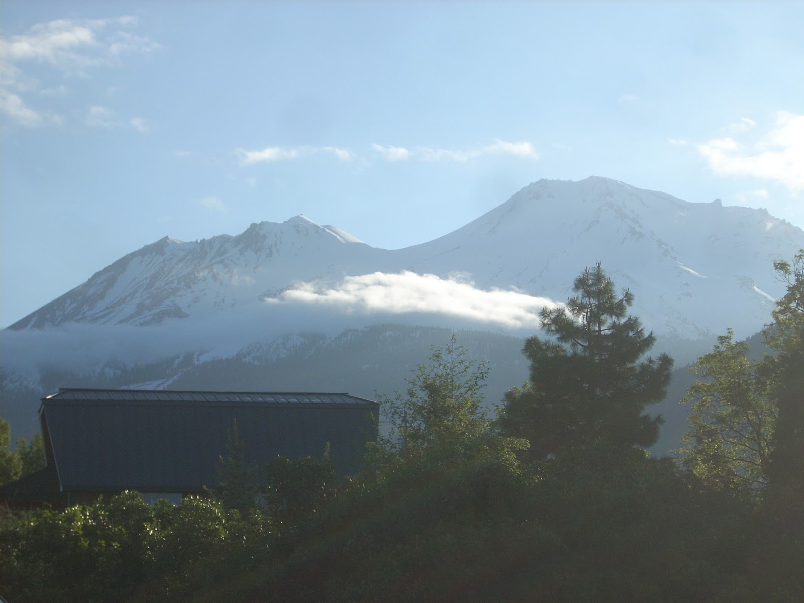
I love this mountain. It isn't California's highest. That designation goes to Mt. Whitney in the Southern Sierra range, but what's cool about this mountain is that it's not part of a ridge of over 14,000 ft. peaks. It dominates the landscape. You can see it for miles away. Unfortunately this trip i hardly saw it at all. It was covered in clouds, but this day i saw her in her full regalia. Snow covered and all.


Randy and Hoa's house.


Their dog - Happy. He is the sweetest most loving dog i've ever known.

Hoa's electric car.

A chemtrail. Randy has sent me lots of info on these. What do you think?
Check out this site.

Randy's medicinal cannabis garden.

Randy's solar panels.

Happy.

I recorded some CDs there. This one was totally in Vietnamese so it was easier to photograph it than write all the info down. Hoa is from Vietnam.


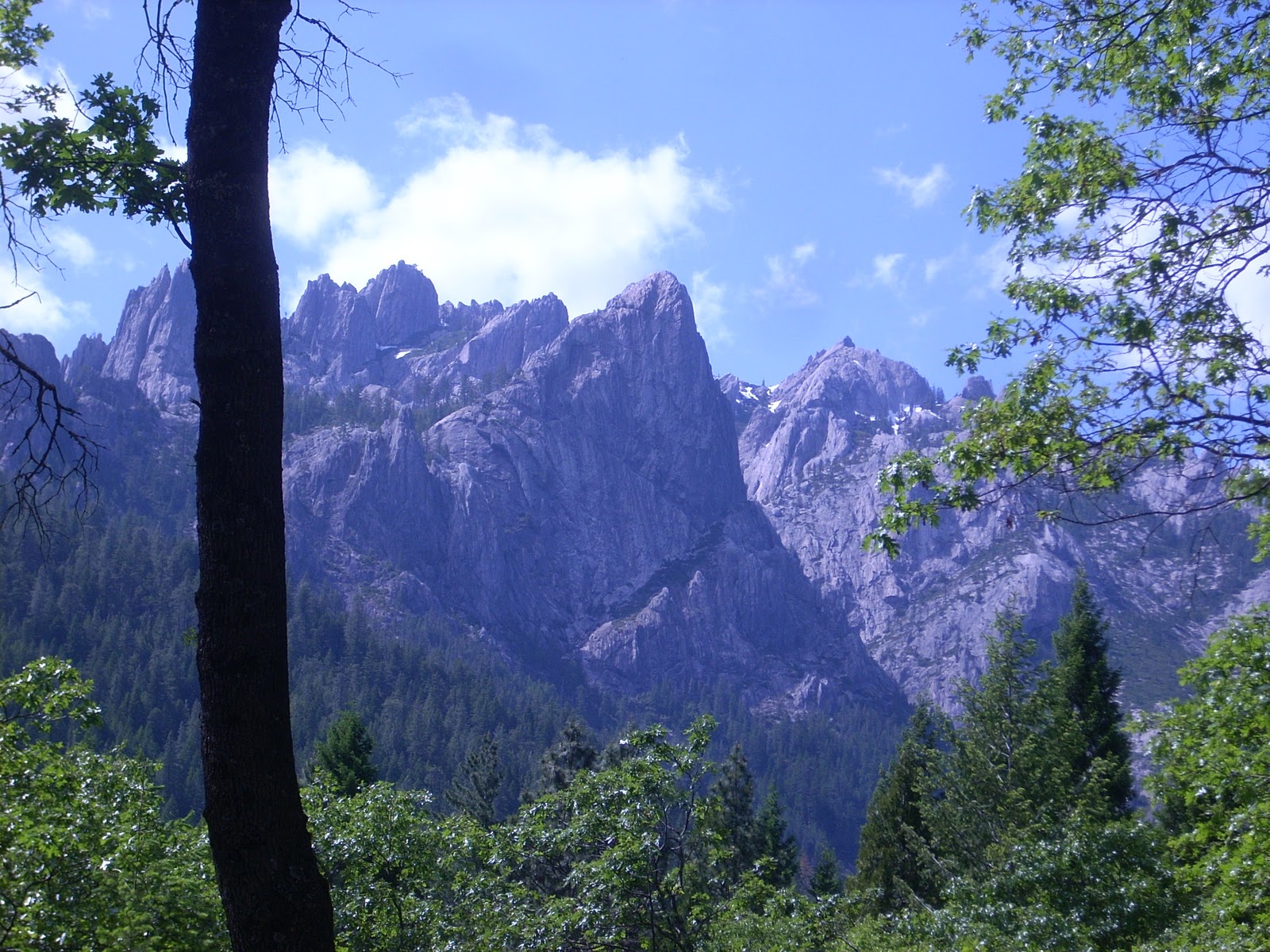
Castle Crags is one of the 70 or so State Parks in California that is destined to close next year due to budgetary cuts. My goal is to visit as many as i can before that happens. 
See the list of closing parks here. Some of them are spectacular.

Randy and Hoa. Hoa means "flower" in Vietnamese.

First glimpse of the crags.


Yours truly humbled by the majestic crags.

A clearing made to view lovely Mt. Shasta.


A close up of the Crags. Left side.

Right side.

Zoom-in of Mt. Shasta.


A happy dog finds his puddle!


These two were actually taken the next morning on the 13th of June before i left.


That was my last leg of this journey. I went back to the Bay Area and resumed life as we know it.

Saturday, June 11, 2011

June 11, 2011 - Southern Oregon to California State Line

You may have noticed the missing day in this blog. I picked up my friend's stuff in Anacortes, WA and then headed back to Seattle to catch the ferry to Bainbridge Island. There i spent the night at her sister's house and got talked into bringing some of her niece's stuff down since she just moved to SF. I left the next morning and headed down to Eugene, OR once again. I stayed the 10th at friends' house in Eugene, OR. I didn't take any pictures these two days and i had a falling out that day with my friends there. I don't wish to discuss it, but it was what it was and i still don't talk to them. Wish them well but i don't want to be around the nonsense any more. After i left Eugene it was the same Interstate 5 that i went north on, however, at Ashland near the California border i had an itch to do something different and i was making good time. I have seen that the Cascade-Siskiyou National Monument was added to the map about 10 years ago. My curiosity got the best of me and i took the scenic route to get to my friends in Mt. Shasta, CA. I turned onto Hwy 66 East toward Klamath Falls so i could find out just what this National Monument was all about. Did find out a little. Check it out for yourself.

Wasn't sure if i was in the Monument or not. According to the atlas, its boundaries actually include I-5, but no signs. Hmmmm.... even more mysterious it was.


The scenery just got more stunning.

Finally! A sign that even acknowledged the existence of it! There was a visitor's center. I picked up a map and realized that there was a lot of private land owners in this area already and they created this monument the best they could to preserve the ecosystems that were still intact.


The Pacific Crest Trail went through here.

This lake was out of the monument and close to the California border.


Actually i was leaving Oregon but i had to get a picture of this sign. I have never seen one anywhere else  in Oregon and it is one of the best "welcome to..." signs i think i've seen.


Back in Cali-forn-eye-ay! Off to visit my friends in Mt. Shasta.

Thursday, June 9, 2011

June 9, 2011 - Bellingham, WA and Larabee State Park, WA

Except for a night in Vancouver, i basically breezed through Washington State to get to Canada. Because of the time and date that i was to pick up my friend's stuff at her friend's house, that's the way it worked out. I stopped in Bellingham, WA on the way up to get gas and drove through it. I picked up a tourist mag about it and it had some cool pics of the downtown, so i decided to drop by on the way back and check it out a little bit more.

Bellingham is where the Alaskan Ferry System begins and ends. Someday i want to experience that journey. 

This building is now the Whatcom County museum.

A zoom in of the top.

Closer to it.

This is the downtown area. Lots of cool monuments, cafes, restaurants etc.


This was the view i saw in their tourist mag.


This is at the Whatcom County Courthouse, which Bellingham hosts as the county seat.

This is one of the most beautiful specimens of the Dawn Redwood i have ever seen. This tree is the third species of sequoia that was found only in China. It is planted as ornamentals elsewhere these days. From the looks of this one, it like Bellingham a lot!


That's it for Bellingham. Wish i had more time to spend, because i thought it was a pleasant city to linger a while. I next headed south down Highway 11 from Bellingham on the coast to Larrabee State Park. It has stunning views of the San Juan Islands in the Puget Sound. I have been disappointed in a lot of the Washington coast because of excess development, but this park proved to deliver the goods for scenic coastline with gorgeous views of some of the least developed islands in the sound.


This beach proved popular with humans and sea gulls alike.


I lingered for an hour here but time was elapsing and i still had 50 miles or so til Anacortes, where i would fill my truck up with my friend's most precious items. The pressure was on!